By: Rick Franzen

Only an historic marker remains at the sight of this Tavern. It is located at the intersections of Sooy Place and Powell Place Roads in Tabernacle.
The Historic American Building Survey (HABS) has concluded that the earliest part of this building was constructed about 1770. It’s most likely that Nicholas Sooy, according to HABS, was the person who built it. This is doubtful as Nicholas did not purchase the property until 1810, and it is unclear in the deed, if a tavern was included in the purchase.
Since Nicholas did own another tavern in Washington Township, it’s possible he added this tavern to his stable of inns. In his will of 1815, Nicholas does mention that he resides in this tavern.
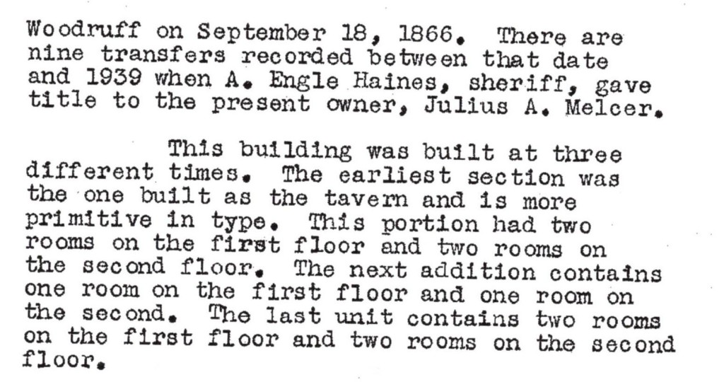
HABS goes on to say that it originally had two rooms on its first and second floors. A later addition contained four rooms, again, two on each floor.
In 1866 it was sold to Benjamin Woodruff and until 1939 there were nine different owners.

In 1806 a Revel Elton purchases the land from Joseph Burr’s estate (Burlington County Deeds Book R Page 287). Revel is a Lumberton resident and purchased the property for $1008.00 in gold or silver money. Two lots were purchased, one on the road from Friendship Mill to Abraham Matson’s which contained 252 acres of land. It also appears that John Burr had the land surveyed (Book BB, page 90). The land is described as a “large parcel of pine, sand and cedar swamp.”
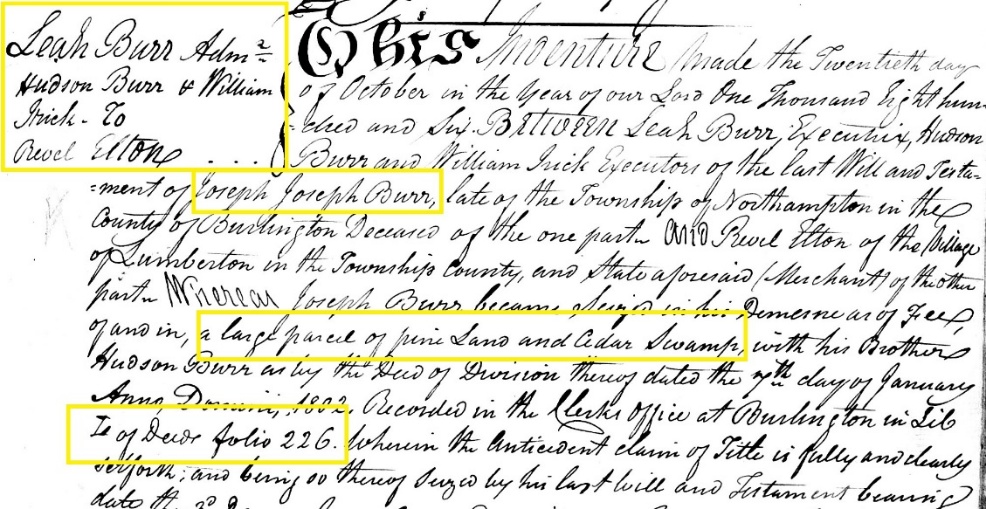
And then in a deed dated the 26th of March 1810 Revel and Sarah Elton sold part of a 365-acre parcel to Nicholas Sooy. The selling price was $2025.00, and the property was located in Northampton Township. The plot contained some 252 acres. It is supposed that later 91 acres were deeded to someone else. perhaps one of the many children of Nicholas Sooy Sr. Based on the cost of the property doubling from deed to deed, it could be that there was a building upon it when Sooy bought it.

Revel Elton was one of at least three generations of Elton who carried the first name Revel. It seems as if all three were very active in their communities.
New Jersey State Supreme Court case records from the early 1800’s are available at the State Archives. Unlike today, these records seem to deal with mostly debt, trespass and appeal of debt. If a trial is held, we are given the names of plaintiff, defendants, witnesses, jurors,” officials” and others participating in the case.
Revel Elton must have been a prominent figure as he was a judge for at least three cases. In 1760, as a Justice of the Peace, he heard the Appeal on an Order of Removal for one Samuel Barwell (Case # 41839). Samuel may have overstayed his welcome or was caught in the middle of a case between the Overseers of the Poor in Chesterfield Township and the Overseers of the Poor in Nottingham Township.
Just a year earlier in 1759 he was the Judge of the Common Pleas Court. This particular case (Case # 19414) was between John Jones Jr. and Joseph Hollinshed and dealt with debt on a bond and trespass. The term “Manucaptor” is used for Hollinshed in relation to a Jonathan Thomas. According to old English law, a manucaptor guarantees the presence of another for a court appearance.
The type of State Supreme Court cases today is certainly far different than those of the early 20th century. And it is such a good thing. We can closely monitor the comings and goings of our forefathers and gain an intimate understanding of life in that time.
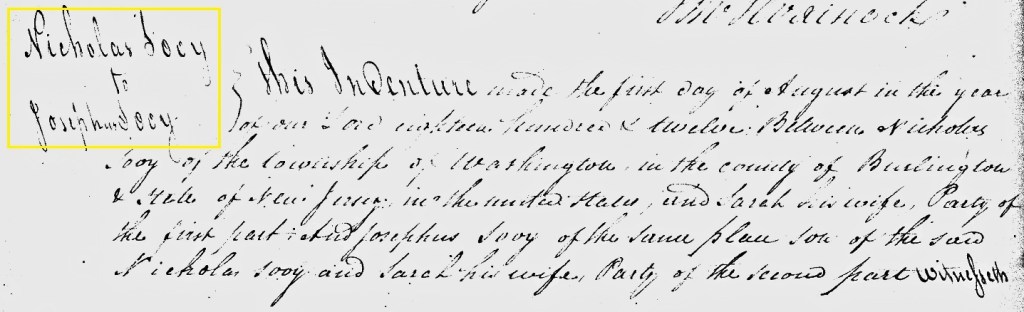
On August 1, 1812, for a nominal sum of $200.00, Nicholas sold 250 acres to his son Josephus. In the deed it mentions that the land originally came from the executors of Joseph Burr’s estate..
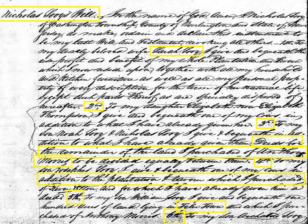
Nicholas Srs’ 1815 will defined how he wishes his estate to be divided. As we see below, he indicated the Tavern should be given: “4th: To my son Josephus Sooy I give and bequeath one of my cows and in addition to the plantation and tavern which I purchased of Rever Elton, and for which I have already given him a deed.” While difficult to read, the last four lines show Joseph’s inheritance of the property.
A question to be raised again is who built the tavern. HABS suggests Nicholas Sooy while the will implies it was one Revel Elton.
The NJ State Archives has many license applications for tavern owners. Most of them are from the 1800’s. They also have a list of tavern owners in 1829/1830. Josephus Sooy is among them.
At this time Sooy Place Tavern is in Northampton Township. Josephus has been “keeping it” for several years and he has “two feather beds available.” There are thirteen original signers (with original signatures), who are “freeholders.”
A signer named Joseph White owned the Kemble Inn (see Kemble Inn) and a signer named J Naylor (see Naylor’s Inn) appear as landowners and they also owned a tavern and/or a stagecoach stop.
.

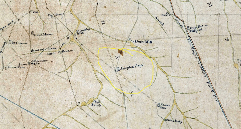
Thomas Gordon’s first map of the area shows “Pine,” the early place name for the Sooy Place Hotel. It also appears to show a building at this location. Note what appears to be a road going from Pine up to Burr’s Mill.

In a State issued geological map, Pine is again noted with what appears to be a structure.

A circa 1840 Burlington County map clearly shows the tavern at the intersection of five roads. They are: Friendship Mill – Johnson Place Roads, today’s Powell Place Road. Sooy Place and South Park Roads, and a road which went from the tavern up to Burr’s Mill. Josephus Sooy is noted as the Inn’s proprietor.
By 1849 a few more buildings appear on the map and the area continues to be known as “Pines.” We can see pretty much the same road configuration and the addition of the homestead of one J Hilliard, on the Friendship Mill Road. The cellar hole for this building can be seen today right next to the roadway.

(Otley JW and Whiteford R, Map of Burlington County, Published by Smith and Wistar, 1849)
The 1850 census revels quite a bit. It is the first U. S. Census to list out names of everyone as well as several other items of interest. We can see nine Sooy family members and seven others who are listed as laborers, all apparently living in the same building. Note the word “hotel” written in the left margin.
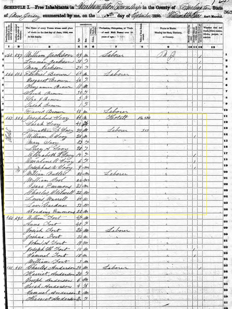
1850 Census (Ancestry.com)
In September of 1855 Josephus’ license request contains the following information. The tavern is now in Southampton Township. And he is requesting “a license to keep an Inn and a Tavern in the house wherein he now dwells.”
And in his 1857 renewal he pays $12.00 for his license. The “subscribers, or freeholders” are:
Guy Bryant John Hillard
Joseph ???? Samuel Butterworth
John L ???? John Woolston
John Cox Charles Haines
William Jones C A Shinn
Alexander ???? John Brown
Kastina Lippencott
There are two maps, one dated 1858 and the other dated 1859, by R K Kuhn and J. D. Janney. The locale is labeled “Pine” on both maps and each shows the hotel owned by J. Sooy. However, the 1858 version shows an “A. B. Moore” residing where the 1849 map listed J. Hilliard as the resident.

Parry W, Sykes G and Earl F W, New Map of Burlington County, Published by R K Kuhn and J D Janney, 1859
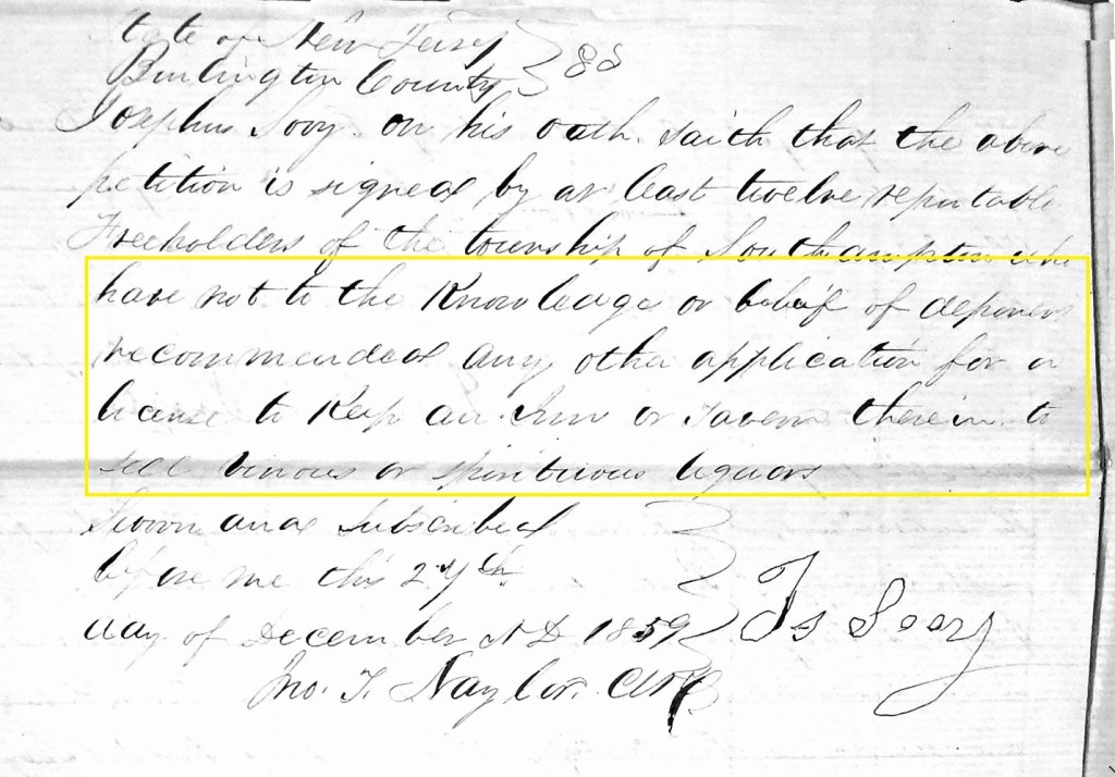
In his 1859 license application Josephus’ license fee is still $12.00. Interestingly, one attachment to the license states, in part, that the signing freeholders have not recommended “any other application for a house, an inn or tavern therein to sell beers or spirituous liquor.” (See section below) The freeholders are:
Guy Bryant William Jones
John Haines John Woolston
Charles Jones J Jones
William ???? Charles Haines
John Broadwater Franklin Thomas
Kastina Lippencott Les?? Carr
(New Jersey State Archives, Tavern License Applications)
In this 1860 William Kitchell map, we can see the area is still called “Pine,” and we can continue to note the road up to Burr’s Mill.

(Kitchell, William, Map of the State of New Jersey, 1860, H G Bond Publisher)
In 1866, the Woodland Township tax assessment list shows Josephus Sooy’s total taxes were $12.60. It’s interesting to note that while the total value of his real estate was $2000, he only paid taxes on $800 of its evaluation. It seems his indebtedness of $1200.00 was not taxed!
When sold by Joseph Sooy to Benjamin Woodruff in 1866, the price for its 161.93 acres was $4250.66. The depth of the lot was over 3000 feet and it ended at Burrs Mill Road.

(Burlington County Deeds Book N Page 66 1866)
This vividly colored map clearly shows the hotel’s location as well as several other buildings on the site.

Beers, Topographical map of Southern New Jersey , Rutgers University, 1872
It seems as if Benjamin Woodruff defaulted on the Sooy family and others’ mortgage in 1873. Dewitt Clinton Hough purchased the property at a sheriff’s sale for $2200. The sale was advertised in both the New Jersey Mirror and the Mount Holly Herald.
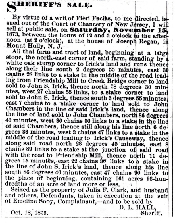
(30 October 1873 Mount Holly Herald)
In Scott’s 1876 Atlas the area is still called “Pine.” We see A B Moore living on the road to Friendship and P Caldwell has a property across the street.
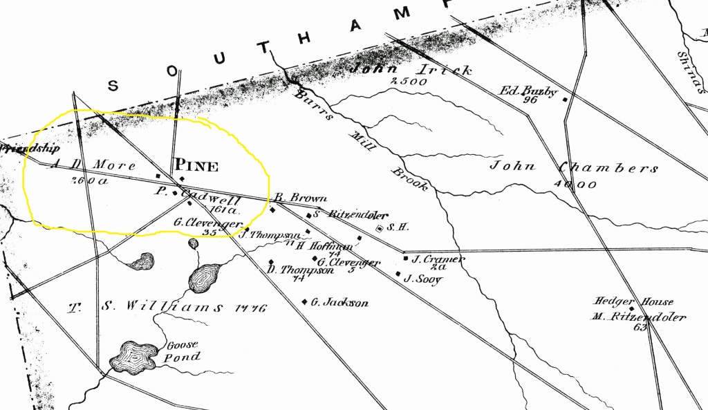
Scott JD, Historical Atlas of Burlington County, Reprint of the Pemberton Township Historic Trust, 2002
In 1883, once again, the property is sold (Burlington County Deeds Book H11 Page 489) by Sheriff Hall. It is now in Woodland Township. This time the buyer is Cornelious Waldman of Saratoga County in New York. Again, the Chancery Court ruled on a complicated mortgage default and ordered the Sheriff to sell the property.
In 1886 Waldman sells the property (Burlington County Deeds Book M11 Page 330) to Adam Caldwell of Clifton Park, NY. It appears the listed sale price is $5.00, and this implies some sort of other consideration between the two New York State residents.
And in 1888 Isaiah Lemunyon purchases the 161.93 acres (Burlington County Deeds Book Q11 Page 41) for $1000.
The first map wherein we see the locale named “Sooy Place” occurs in the 1888 Cook Geological survey map.

(Cook G and Smock J, The State of New Jersey Surface Geology Map, 1878)
In 1902 Lemunyon was desperate to sell the property. During the course of the year, 20+ ads appeared in the Mount Holly News. They all were identical to the one below.

(25 March 1902 Mount Holly News)
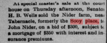
After 17 years of ownership by LeMunyon, the property passes (Burlington County Deeds Book 384 Page 135) to Joseph Nider, a Jersey City, NJ, resident. The sale price is $800.
Joseph Nider sells to Anthony and Alex Nider (Burlington County Deeds Book 409 Page 441). Obviously, both are related to Joseph Nider, but the circumstances or relationship is not known. The selling price is $2500.
A Special Master, Harold Wells, grants a deed (Burlington County Deeds Book 528 Page16)to one John Nider, a Tabernacle Township resident. Again, the Chancery Court had ordered the sale, and it was advertised in Mt Holly Newspapers. The sale price was $350 and, it seems, assumption of a $350 mortgage
.


(11 July 1916 Mount Holly News)
In 1917 the 161.93-acre property leaves the Nider family and is sold to Antoni Chinstyk for $2000 (Burlington County Deeds Book 533 Page 309).
Two days later Antoni Chinstyk quickly sells to John Chinstyk for $1000 (Burlington County Deeds Book 533 Page 313).
In the height of the depression during 1929 there is another Sheriff’s sale via the Common Pleas Court (Burlington County Deeds Book 740 Page 211). The buyer is Julius Melcer of Mount Laurel and one Earl Cline. Their winning bid was $900.
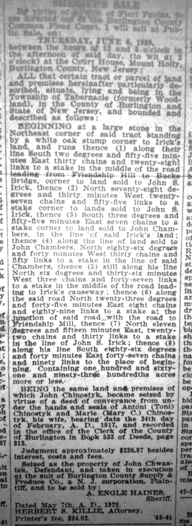
(May 1929 New Jersey Mirror)
Dorothy Streng, of Camden, NJ, purchases the 161.93 acres from the Melcers and Clines, for the listed price of $1.00 in 1933 (Burlington County Deeds Book 808 Page 57).
A little later in the year she sells the acreage to Anna Melcer and Liddie Cline (Burlington County Deeds Book 808 Page 60). Seems like a strange arrangement.
Anna Melcer, et al, now sell the property to Dorothy Streng (Burlington County Deeds Book 837 Page 134).
As the flip flopping continues, Dorothy Streng resells the property (Burlington County Deeds Book 837 Page 136) to Anna Melcer for $1.00.
In 1936 Charles Boyer describes the tavern as “On the road from Speedwell to Vincentown, at what is now called Sooy Place. Andrew Elverson kept a tavern from 1810 to 1817 (edit, actually Revel Elton). This house is still standing, was called the Pine Tavern and was an important stopping place for travelers going to the Speedwell Furnace.”
In the 1930’s the Historic American Building Survey was taking place. Luckily the 19 Pines was selected for review. It resulted in a fantastic four-page document and told us a lot about the history of the tavern. It is reproduced in its entirety, without the bibliography, to help you understand the written historical record of the site. Below are several pictures and drawings contained within it.
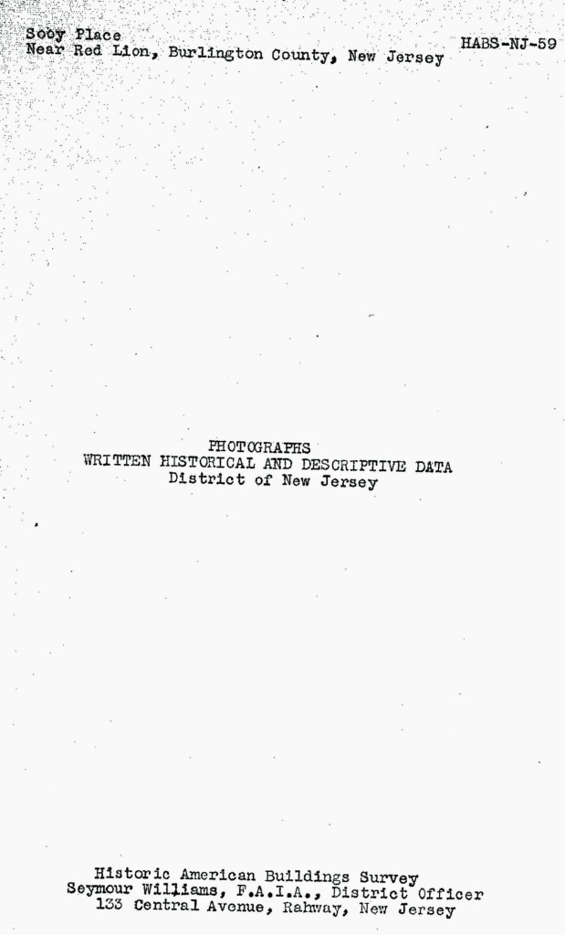


(Williams, Seymour, Historic American Buildings Survey, 1938, Library of Congress)
The HABS had some 18 or so pictures and drawings within it.
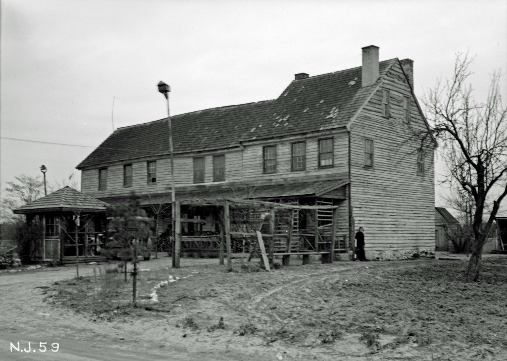
(Williams, Seymour, Historic American Buildings Survey, 1938, Library of Congress) Note the person standing against the right side of the structure.
First floor plan ((Williams, Seymour, Historic American Buildings Survey, 1938, Library of Congress)
)Second floor plan (Williams, Seymour, Historic American Buildings Survey, 1938, Library of Congress)
A direct quote from Henry Bisbee’s book on place names of Burlington County.
“Located between Friendship and Johnson Place on the eastern border of the Township. Named for J Sooy, who operated the Pine Tavern at this place around 1817. At this date it was known as Pine Tavern, and the 1849 map so notes it. According to Boyer, the tavern was an important stopping place for travelers on their way to Speedwell Furnace.”
In 1947 2.08 acres are sold from the original tract to Alice Hansell by Julius and Anna Melcer (Burlington County Deeds Book 1034 Page 453).
On a cold February Friday, in the evening hours, an overheated “chunk burner stove” caused a fire which all but destroyed the Sooy Place Inn. Here is the story as told in the Central Record.

24 1949 February (Central Record)
In 1959, Julius Melcer, now a widower, for $1.00, sells to his nephew Oran Rives, 1.11 acres (Burlington County Deeds Book 1412 Page 189). This is lot number one of a subdivision approved earlier in the year. Julius had inherited the land after the 1958 death of his wife Anna. The deed notes that this is part of the 161 acres of land Anna Melcer purchased from Dorothy Streng in 1935.
Just a little later in 1959, Julius, for $1.00, sells to his nephew Carlton Rives, 1.12 acres. This is lot number two of a subdivision approved earlier in the year. Julius had inherited the land after the 1958 death of his wife Anna. The deed notes that this is part of the 161 acres of land Anna Melcer purchased from Dorothy Streng in 1935. (Burlington County Deeds Book 1412 Page 193).
Julius Melcer and his new wife Elsie sell for $1.00, 3.834 acres, to Frederick Gall (Burlington County Deeds Book 1507 Page 869) in 1962. The deed notes that this is part of the 161 acres of land Anna Melcer purchased from Dorothy Streng in 1935.
And finally in 1962 Julius and Elsie sell the rest of the 161.93 acres to Hyman Frank (Burlington County Deeds Book 1514 Page 729).

Williams, Seymour, Historic American Buildings Survey, 1938, Library of Congress
