Tabernacle’s Friendship Property by Rick Franzen ©
Our first inkling of a sawmill at Friendship comes from a November 1711 document recorded with the West Jersey Proprietors (West Jersey Loose Records 1711 – Hayns, John) now on file in the NJ State Archives. The West Jersey Loose Records date to the 1600’s and were one of the many sets of documents use by the Proprietors of East and West Jersey to document land transactions. Eventually all records were donated to the State Archives. In short, the process by which land was acquired in the Colony went something like this. In West Jersey the Proprietors allocated the land via a process that usually had five steps (Using the records of the East and West Jersey Proprietors, Joe Klett, 2014).
- A “dividend” was declared, and a share of acreage rights was apportioned to shareholders.
- The shareholder applied for a “warrant.”
- The Surveyor General received the warrant and laid out the tract of land.
- A “return of survey” was completed and then approved by the Council.
- A deed was granted to the shareholder.
So our 1711 document seems to be from step four above. In it two surveys are noted, one of 50 acres and one of 2240 acres. With the larger survey, mention is made of seven individuals sharing in the land (the shareholders). The land is described as “On a branch of Ancocas Creek, to a cedar swamp road, on a creek called Cuttuxink, Burlington County.
Here is a copy of the greater part of the survey. You probably will not be able to read it but should be able to get the basics of it.

The seven individuals (each with an equal interest of 340 acres) are John Haines, Richard Haines, William Haines, Thomas Wilkins, John Borton, Benjamin Moore and Jonathan Haines. This information is also contained in the 1902 book, by Richard Haines, entitled “Ancestry of the Haines, Sharp, Collins, (and nine other) Families” published by Sinnickson Chew and Sons Company. This book also identifies the survey as the “Friendship Tract.”
Many of the documents of this early era tended to confuse us a bit because they seemed to indicate that the Friendship area was in Evesham Township. However, a quick look at the history of that Township (https://evesham-nj.org/resident/history) shows that,when created in 1692 as one of 13 townships in Burlington County, it included today’s Shamong and Washington townships. In 1802 Washington Township was carved out. Shamong, established about 1853, was carved out in that year.
From the “Clovercroft Chronicles 1314-1893” by Mary Haines we have confirmation that Jonathan was the son of John. She further states that the 2290 acres were purchased after the survey by John, “his brother Richard, son Jonathan and others.” The land was located at the Friendship Mill on a branch of the Rancocas. “After the survey was made, they bought the Indian title and received deeds from the chief We-Sosig.” (This is not mentioned in the land allocation process)
The relationship of some of the individuals is straight forward. But first a little history. This information comes from the Richard Haines book. In the spring of 1682, the Haines Family left Downs, England on the ship “Amity.” They arrived in Burlington that fall, without the father Richard Haines, who had died on board. While Richard and his wife Margaret had at least six children, three of them were involved with the land survey. They were John, Richard and William.
We do not know the year when the sawmill was constructed, but we do have a reference to its existence in 1730. In the Richard Haines book, Haines discusses a sawmill built by the Haineses at Chairville (Medford) which was in use until 1730. He goes on to say “…. when they sold the land and mill site, having built a mill at Friendship a few years before. John Peacock was a sawyer at Haines’ Creek Mill until Friendship Mill was built and then John was a sawyer at Friendship.”
However, we do have a document, dated in the spring of 1714 (Mill Agreement – Burlington County Historical Society) which outlines the legal partnership between six of the seven original partners. William Haines is not a part of the group. In a 1753 deed (Enoch Haines to Charles Read – West Jersey Deeds Book K, Page 460) mention is made that William had released his share to his partners. So, William’s departure from the partnership occurred prior to or during 1714.
It appears that the six individuals (John Haines, Thomas Wilkins, Richard Haines, Jonathan Haines, John Borton and Benjamin Moore) share equally in the costs of construction, repairs, and maintenance of the property.
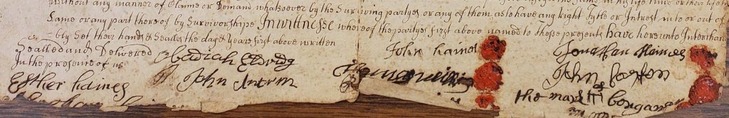
While agreed upon in 1714, the document may not have been “filed” ( with the West Jersey Proprietors) until 1743/4. It is on this date that Judge Thomas Shinn signs the document and affirms that it was agreed upon in 1714.
In addition to five of the six original owners signing the form, we see the names of at least two witnesses. They are Obediah Eldridge and Esther Haines (probable sister of John Borton).
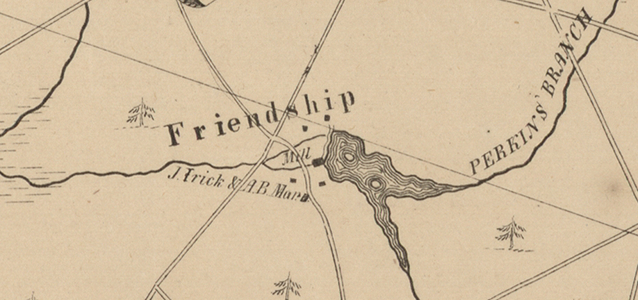
But just exactly where was the 2000+ acres located? Without a survey map, at this time we can only speculate. A land plot, using the dimensions shown in a 1744 deed, shows the land to be somewhat triangular. It may be following the course of Friendship Creek or Bread and Cheese Run.
However, we can trace some ownership if we look at the wills and deed transfers of the partners.
WILLS
- John Haines
In his 1728 will, John Haines leaves his share in the sawmill to his sons Josiah and Caleb Haines and nearby lands to son Jonathan. From the 1902 book we see his will quoted as follows “ I also give to my said son Josiah Haines, his heirs and assigns forever, the one full equal half part of my sawmill and my land thereto.” And, “I give and devise unto my son Caleb Haines all the remaining full equal half part of my said sawmill and land thereto belonging.” For Jonathan we read “I give unto my said son Jonathan Haines, his heirs and assigns forever, all my part of the above mill pond or the land that said pond of water covers.”
John Haines lived in a house, known as Friendship Farms, on Fostertown Road in Medford. It is listed in the National Register of Historic Places (in 1976). The report establishing its history also provides a solid genealogy of the family and mentions the 2240-acre purchase of the Friendship tract.
- Richard Haines
Richard Haines died in 1746 and his will is dated December 1744. There is no mention of a sawmill in the will.
- William Haines
William Haines gave up his share of the tract of land about 1714 and his will, logically, makes no mention of the sawmill property.
- Jonathan Haines
When Jonathan Haines passes in 1729, he leaves a ½ share to his son John. No mention is made of the other ½ share.
- Benjamin Moore
Benjamin Moore died in 1737 and his son John died in 1812. John’s will gave his share to Hosea Moore, his son. Hosea died in 1838 and it is entirely probable that his son Aaron B Moore is the individual mentioned as an owner (along with J Irick) in the 1849 Otley and Whiteford map.
Both the 1858 Kuhn and Janney map, as well as the 1859 Lake and Beers map, mention J. S. Irick and A. B. Moore as owners of the sawmill. But by 1876 ( in the Scott Atlas), A. B. Moore is the only owner noted. A. B. died in 1877. Before we take a look at who took over his shares, we need to review two other of the original owners of the tract.
- Thomas Wilkins
Thomas Wilkins died in 1791. In his estate his interest in the sawmill was left to his grandsons Jacob and Thomas (their father was another Jacob Wilkins). Grandson William is probably the person who sold the Tabernacle Church and Cemetery plot to the 28 cemetery owners.
- John Borton
John Borton may not have ever owned any of the mill. According to the 1753 deed mentioned earlier, he too gave up his share his share of the ownership circa 1714.
- William Burr
Somehow, William Burr did end up with a piece of the action. In his will of 1795, he mentions his share of the Friendship Sawmill, along with “lot of land for school house and residue of plantation, to be sold for debts.” How Burr obtained a share of the mill is not yet clear. Henry Bisbee, in “Sign Posts,” mentions that William Burr operated the sawmill in 1795. His source of information was William’s will and Woodward and Hageman’s “History of Burlington and Mercer Counties.”
DEEDS
- Richard Haines
While Richard’s will is silent about the sawmill, we do have an indenture (from the Burlington County Historical Society) in which Richard sells his share of the sawmill to his sons Carlile and Enoch. Dated December 10, 1744, it is written about the time (13 December 1744) Richard’s will was developed. So, Richard’s share of the mill went to two of his sons. The selling price was twenty pounds for Richard’s one fifth share of the mill. The one fifth share has changed from a one seventh share after John Borton and William Haines left the group.
A 1753 deed (West Jersey deeds Book K Page 460) details the sale of Enoch’s share. It’s listed as a one seventh share and is sold to Charles Read (of ironmaster fame?) for 90 pounds. The deed also details ownership changes for four of the original seven partners.
There is a 1762 indenture in which Carlile Haines sells his share of the mill to his son Ezekiel Haines. The site is called Haines Mill and it sits upon 2190 acres. This is fifty acres short of the 1711 survey number. However, if you add in the additional 50 acres mentioned in that 1711 survey, the 2240 acres of the first survey is equaled. So the question is, was the mill also known as the Haines Mill, or both the Haines Mill and Friendship Mill, or perhaps the Haines Mill at Friendship?
For a possible answer we can turn to an 1887 document. When Albert Jones and Lewis Sharp purchase a property of 4.24 acres, its location is noted as “On the southerly side of Haines Mill Stream now called the Friends Mill Stream, Woodland Township.” Sharp and Jones were later owners of the property and played a major role in the establishment of the Amity Cranberry Company.
Meanwhile, Ezekiel sells his share to Bethuel Moore, a son of Benjamin Moore.
Meanwhile, Ezekiel sells his share to Bethuel Moore, a son of Benjamin Moore. (See WJ deed Haines to Moore Volume A-N page 383, NJ Archives)
So, by 1753 Richard Haines’s 1711 share has passed on to Charles Read and Ezekiel Haines.
- John Haines
There are no John Haines deeds as he bequeathed his share to sons Josiah and Caleb.
- William Haines
No deeds since he left the partnership early on.
- John Borton
No deeds since he left the partnership early on.
- Jonathan Haines
In the 1753 deed it is mentioned that Jonathan left his share to his sons John and Nehemiah.
- Thomas Wilkins
In his will, Thomas left his share to grandsons Jacob and Thomas.
No relevant deeds have yet been found, but we can trace ownership through to Hosea Moore.
In the 1782 Article of Agreement between the owners (Burlington County Historical Society) we are given the actual breakdown of who owns what percentage. Even though the 1711 survey listed seven partners, and the 1714 agreement notes six, shares in the ownership are based on the number seven.
This leads to speculation that one of the original seven (William Haines) sold or granted their share to another. And because John Moore holds “three sevenths and a quarter,” it is likely him.
Here is the breakdown:
John Moore “three sevenths and a quarter of a seventh” (3.25 shares)
William Burr “one fifth and a quarter of a seventh” (0.25 shares)
Bethuel Moore “holding one seventh” (1 share)
John Moore Jr “holding half a seventh” (0.50 share)
Benjamin Wilkins “holding one third of a seventh” (0.67 share)
Thomas Wilkins “one sixth of two sevenths” (0.33 share)
Jacob Willits “one sixth of two sevenths” (0.33share)
Mecajah Wilkins “one third of two sevenths” (0.33 share)
William Wilkins “one third of two sevenths” (0.33 share)
(Share amounts provided by Rich Watson)
When added together the total is 6.99 shares, a shortage of 0.01 share, which is due to rounding. This is a very confusing allocation method for us in today’s world, but certainly made sense to the participants in the 1700’s.
However, most revealing is the owners who are not listed. There are no Haineses.
So we can document that by 1782 the Haines Family interest in the sawmill seems to have faded. One can wonder if there may be a connection with the Revolutionary War, since it ended in 1783. The Haines’s were Quakers and very possibly could have been Loyalist. Thus, they may have lost their holdings when the British lost the war.
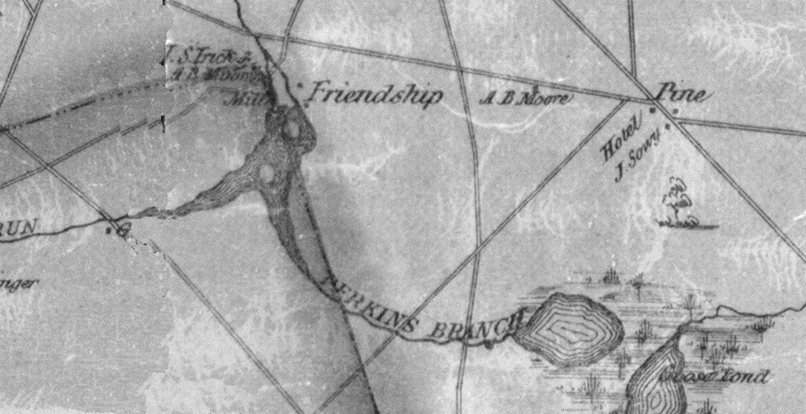
In 1812 a man surnamed Watson, published a map of New Jersey. Friendship is noted on it, sharing lettering the same size as other nearby and more developed areas (Hampton Furnace, Union Forge, Vincentown, etc.).

It is also interesting to note that in 1841 and 1842 John Irick obtains a share of the sawmill from two Haineses, who were acting as executors for the estate of one Samuel Haines.
In the 1849 Otley and Whiteford map the sawmill owners are listed as J. Irick and A. B. Moore.
A summary the original seven owners and disposition of their shares is:
John Haines left his two sons Josiah and Caleb equal shares in 1728.
Richard Haines sold his share to his Carlile and Enoch in 1744.
William Haines withdrew from the partnership.
Jonathan Haines left one half share to his son John in 1729.
Benjamin Moore passed his share to his son Benjamin, then it went to his son John, then to his son Hosea and then to his son Aaron.
John Borton withdrew from the partnership
Thomas Wilkins left his share to his grandsons Jacob and Thomas.
Even with the wills, deeds and potential census data, tracing ownership changes to A. B. Moore and John Irick is troublesome. While we can clearly see the line of succession from Benjamin to Aaron Moore, we do not know how large a share Aaron ended up with or from whom it all came. So next we will try to pick up the ownership line with Moore and Irick to see what their era contains.
Aaron Bishop Moore (1807-1877) is the son of Hosea Moore (1772-1838). Hosea is the son of John Moore (1736-1812) and John is the son of Benjamin Moore Junior (1700-1795). In turn his father is Benjamin Moore Sr. (1665-1754) one of the partners from the 1711 survey.
But by Aaron’s time of involvement, the property has been broken up into many sub parcels, making it almost impossible to follow exact lines of ownership. So we will present what information we have and hopefully provide some thoughts on what was occurring.
In 1737 Benjamin Moore Sr. granted land to Benjamin Moore (his son) and to a Joseph Moore (review deed again)
In 1744 Enoch Haines granted land to Benjamin Moore Jr.
In 1851 the executors of Samuel Haines advertise the sale of 16 acres of pine land near by Friendship Mill. Samuel may at one time had an ownership interest in the sawmill.
In 1858 we have the following happening, which appeared in the June 3rd, 1858 newspaper, The Monmouth Inquirer.
“ Painful accident – Alfred Moore, son of Aaron B. Moore, living near Tabernacle, Shamong Township, Burlington County, says the Mount Holly Mirror, met with a serious accident on Wednesday, the 26th inst. It appears a boy had borrowed a gun of Moore, and went in quest of crows, and on returning had left it cocked. Moore then placed the gun under his arm, as is supposed to have a chat with the boy, when the gun went off, lodging the whole charge in his shoulder, tearing the flesh in a shocking mannar, and it is feared the wound will result fatally.”
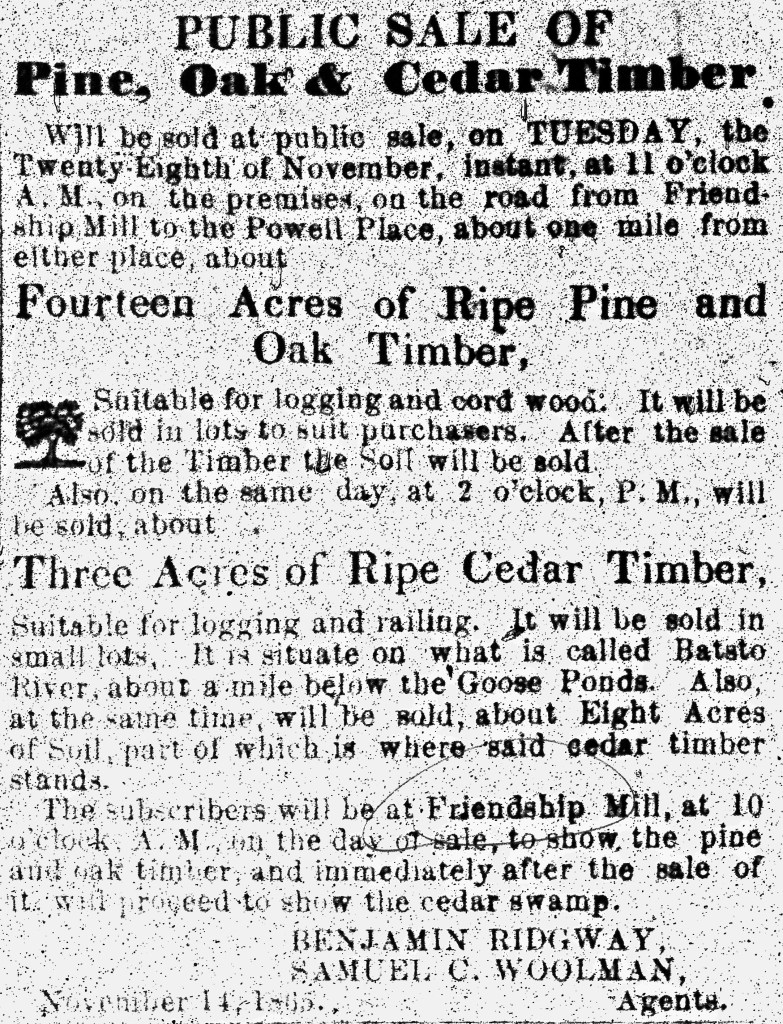
An 1865 ad in the New Jersey Mirror mentions the sale of 14 acres of “ripe pine and oak timber.” It is located on the road from Friendship Mill to the Powell Place. Also in the same advertisement is the sale of 3 acres of ripe timber, on the Batsto, about a mile below Goose Ponds. While the sale agents are mentioned (Benjamin Ridgeway and Samuel Woolman), the owners are not. But the “subscribers” will be at Friendship Mill to show the wood lot.
Before his 1877 death, Aaron sold two parcels of land to his daughter Adelaide for $2500. This particular deed lists two tracts of land, one of 237.32 acres and the other of 41.69 acres. Both plots had passed to Aaron from his father Hosea.
1878 23 May New Jersey Mirror
“The old Friendship Mill has been demolished, and the pond is to be turned into a cranberry bog, by its owner, Gen. John S. Irick.
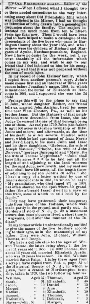
In 1878 and early 1879 The New Jersey Mirror published a history of Friendship Mill. There are four articles, two of which are “corrections’ to what had been earlier written.
From the New Jersey Mirror 26 December 1878


New Jersey Mirror 2 January 1879
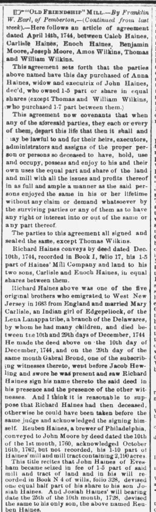


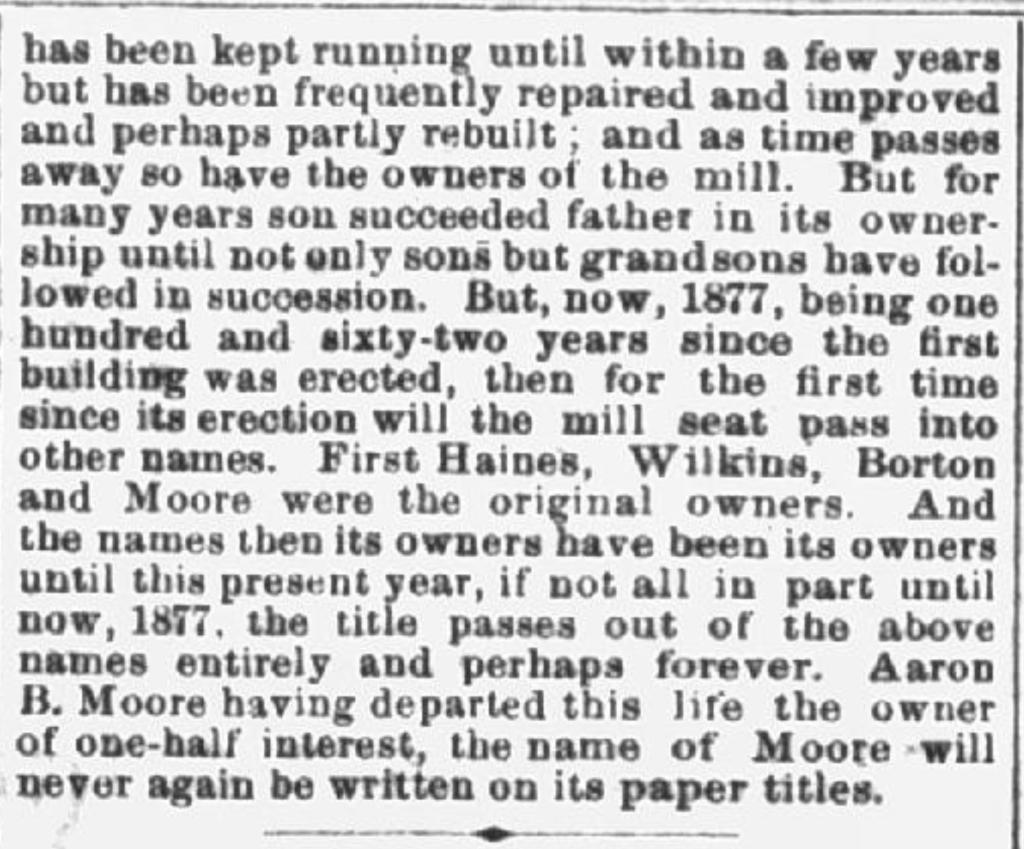
New Jersey Mirror 9 January 1879

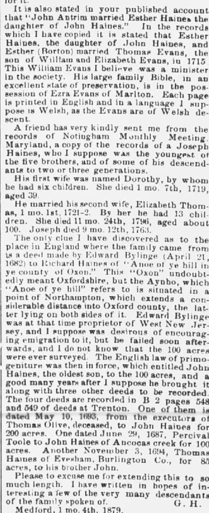
New Jersey Mirror 6 February 1879

In 1880 we do have a deed which transfers part of Aaron’s land (he is now deceased) to John Irick. Aaron had passed in 1877 and in his will made his wife Ascah and his friend Franklin Earl, executors. The plot of land was part of a larger parcel, some 41.69 acres, Aaron had sold to his daughter Adelaide in 1875. The 1880 deed seems to be the last one involving the Moore family.
The probate of Aaron’s will in 1880 is interesting. It documents the distribution of his assets and establishes that his liabilities were higher. After the sale of his holdings and receipt of other incomes, his estate still owed $866.80. The assets of the estate totaled $7601.11 and the liabilities were $8467.97.
A lot of timber and “soil” was sold, as well as at least 12 plots of land totaling about 277 acres. In addition to the sale of the “mill” to John Irick (some 42.29 acres), we also see the sale of the Fox Chase Farm (40.6 acres) to William Irick. And “opposite the Fox Chase,” 6.55 acres to J. Irick. These final transactions seem to end the Moore Family’s direct connection with Friendship Mill.
There are no less than four deeds which link John S Irick to the Friendship site. Two maps, the 1849 Ortly-Whiteford and the 1859 Kuhn and Janney also display his name. More connections certainly exist and eventually will be located.
In 1842 John Chambers sells Irick 4 acres for $1000. The land contains a sawmill and the legal description of the land begins at “the middle of the bridge crossing Friendship Mills Creek on the road leading from Red Lion to Sooy’s Tavern.” John Chambers was not one of the original founders of the site and seems to have obtained a “half-moiety” from Thomas Haines and George Haines via deed (Burlington County deeds Book II 3 Page 325) in 1832.
The other “half-moiety” was obtained in 1841 from George Haines (Burlington County Deeds Book II 3 Page 327). George and Thomas were executors for Samuel Haines in 1832, but it seems not in 1841.
Another notable event of this era was the establishment of Woodland Township in the year 1866. The Friendship stone marker is noted not only as a boundary line for the new township, but also as the former boundary for Shamong and Southampton townships (Tabernacle will not be incorporated for another thirty-five years).
By 1880 Aaron Moore’s estate has sold his land to John Irick and not too much later, (in 1886) Irick sells the land, for $1000 to Albert W. Jones. Jones pays $200 cash and mortgages the remaining $800. In the deed (Burlington County deeds Book 11, Page 459) mention is once again made of the Friendship Cornerstone. John Irick dies in 1894 and, quite naturally, no mention is made in his will of Friendship Sawmill.
From: 1878 23 May New Jersey Mirror
“The old Friendship Mill has been demolished, and the pond is to be turned into a cranberry bog, Gen. John S. Irick”
In 1891, in his annual report, The State Geologist acknowledges that the sawmill on Friendship Creek, owned by Albert Jones, is “not in use.”

Albert Jones, born in 1851, is a life-long area resident who, on his maternal side, descends from the Willits family. In the 1900 census he lives in Woodland Township and is a cranberry farmer. It’s quite possible he is living at the sawmill site, as part of this was in Woodland, prior to Tabernacle’s incorporation. By 1905 he is listed as a “landlord” in the State census.
In 1910 we do see that the sawmill is once again operational as both Obadiah and Alexander Foulks are laborers in a sawmill and provide a home for Albert. Albert seems to also have a job in the lumber industry. Their residence is on Friendship Road in Tabernacle.

On 9 July 1909 the Amity Cranberry Company was founded 1909 Corporations of New Jersey – State Library). Albert Jones (of Medford) was the Secretary, while R. S. Sharp, also of Medford, was the treasurer (27 July 1909, Mount Holly Herald). The President was Theodore Bailey of New York City.
At first the corporate agent was Frank Earle of Egbert Street in Pemberton, but on December 13th of 1909, this was changed to R. S. Sharp of Medford. $25,000 in capital stock was authorized with 250 shares valued at $100 each. The company actually began with just $1000.
The $1000 represents just 10 of the 250 shares. According to the incorporation files (Burlington County deeds Book F Pages 208-214, Burlington County Clerks Office), those ten shares were distributed as follows: Henry Ward of Philadelphia, five shares; Carlton Geist of Medford, 4 shares and Graham Woodard of Philadelphia, 1 share.
Just after the July incorporation, Albert Jones sold his acreage to Amity Cranberry Company for $1500. The land then contained 201.12 acres. Listed also as a grantor are Lewis and Rebecca Sharp. While Jones bought the land from John Irick in 1886, it is not yet clear how the Sharps obtained a later interest in it.
On April 11 1918 a Sheriff’s sale of two properties owned by Albert Jones is completed. (March 19, 1918, Mount Holly News). This was a result of a civil suit by Keturah Irick Lippincott, granddaughter of John Irick. Possibly Albert had defaulted on his $800 mortgage from 1889. One plot is 42.28 acres. The other’s size is not mentioned other than it was sold by John Irick’s wife to Albert Jones.
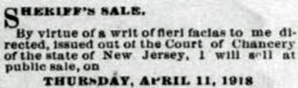
Later on (May 11, 1918) as the executrix for Lewis Sharp, Rebecca Sharp, along with Albert Jones, sells a 42.28-acre plot, as well as a 4-acre plot, to Amity Cranberry Company. Proceeds from the sale total $6,600. A third sale of a six-acre plot is also included and this is a piece of land which John and Emaline Irick had sold to Albert Jones in 1886. Complicated? Quite! In fact, it becomes so complicated, we’ll skip the sale of another tract of land containing 0.73 acres!
Before we move on to the Spaeth era, we can take a look at the Sharp family. Dr Lewis Sharp was a physician who had lived on Union Street in Medford. He was born in 1841 and did not marry Rebecca Bailey until 1904. When he passed away in 1910, Rebecca must have been his executor, as that is how she is identified in the 1918 sale of Dr Lewis’ share in Friendship.
This was Rebecca’s second marriage. Her first was to Edward Sharp, Lewis’ younger brother. It ended with his death in 1888. The Theodore Bailey of New York City more likely than not, is Rebecca’s brother (Sharp/Steele Family Tree on Ancestry .com). Born in Pennsylvania, his 1928 obit asks Philadelphia newspapers to “please copy.” This was a common practice before the era of today’s split second and mass communication. Another name which pops up in some of the deeds is Beulah Given (1876- ?). The limited information we have on her shows her husband is Dr. Horace Given and that they married in 1901. It’s quite possible that she is the sister of Albert Jones, as they both appear as siblings in the Amoore Family Tree at Ancestry.com.
The Spaeth era begins about 1938. We have a fascinating appraisal of the Amity Cranberry property completed in 1936 by Medford Realtor W. H. Bowker. Not only does it describe some 348 acres of land, but also four dwellings which were on the site.
Upper Lake reservoir – 40 acres – value $1000
Center Lake – 50 acres with 32 acres in cranberry plants – value $10000
Lower Lake – 42 acres – gates and dam out – value $1000
Timber land – 100 acres – cut and uncut – value $3500
Brush land – 11 acres – value $55
Cranberry land – 5 acres – value $250. This totals 248 acres with a value of $15805.
The buildings are described and valued as:
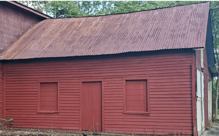
- 2 ½ story frame dwelling east of the lower pond 24×30 with one story kitchen 6×12 and porch. This sounds very much like the former schoolhouse which became the home of the Spaeths and was torn down some 15 or 20 years ago. Yet may not be as the Spaeth building is on the west side of the lake and is only one story. Value is $1000.
- Cranberry storage House on west side of lower pond, frame 20×60 with ell 20×20. The foundations of this building can easily be seen today. The building was torn down prior to 2000 as it was falling apart. While the 20×60 measurement holds true, the 20×20 ell is actually 20×24 feet. Value is $1000.

3. Frame office adjoining. Still standing, seems structurally sound, but needs rehab. Value is $50.


4. Frame dwelling west of the cranberry storage house, 15×25. This two-story building is still standing and has had several additions placed upon it. Its original dimensions seem to be 15×23. One addition to the north side measures approximately 24×47 feet, while a smaller “lean to” measures 8×23 feet. The original house is clearly visible within the added structures. Value is $250.

The total value of the land, buildings and personal property is just over $18,000.
A 1936 tax bill for Amity shows an annual tax of $70.80 for 100 acres “bog and brush.” Undoubtedly this is for the aforementioned cranberry acreage, even though the lot size is different.
In our possession we have a short “recollection” of the property, believed to be written of the time when the Spaeth’s purchased the land. Here is a relevant excerpt of it.
“Friendship was a forgotten town of New Jersey. In 1938 when the property was purchased by the Spaeth Family, years of neglect had taken its toll. Most buildings were falling down, and everything was overgrown with brush. Trees were covered with masses of briars. The dam on Friendship Creek was out and the cranberry bog grew up in trees.
The one-room schoolhouse was built in the nineteenth century. It was restored and became the nucleus of the Spaeth home which was built around it over a period of years. The ground was cleared and made productive.
The remains of the old sawmill could be seen and some timbers from the water wheel were visible, but now are rotted away. In the early eighteenth century a canal was dug by hand to divert the water from Bread and Cheese Run to furnish waterpower to run the sawmill. Unfortunately, this canal was dirt filled in 1986 or 1987.
Years ago, the dam on the lower lake (formerly a cranberry bog) was a stagecoach route going to Chatsworth and the shore. Not far from where the sawmill was is an old spreading oak tree in whose roots can be seen a large iron stone. The stone marks the location where Shamong, Woodland and Southampton Townships met. Tabernacle Township was carved from the three townships and in 1901 Tabernacle Township was Chartered.”
The Spaeths did not purchase the entire Amity Cranberry Company Tract of 248 acres. A review of available deeds shows they did purchase the following three tracts totaling 29.02 acres.
The Spaeth deeds are dated October 7, 1938. The deed with the largest plot size is for 22.29 acres (Burlington County deeds Book 894 Page 385). The grantors are Bessie (Beulah) Given and Daisey Davis, Executrixes of the last will and testament of Albert Jones, deceased.
The second deed is for a six-acre plot (Burlington County deeds Book 894 Page 388). Its grantor is Bessie Given, widow.
And finally, the deed for .073 acres was granted to the Spaeths by the Amity Cranberry Company (Burlington County deeds Book 894 Page 391).
On the 21st of October in 1938, the Spaeths enter into an agreement with Amity Cranberry Company. Bessie Givens represents the Company. Amity is granted the right to dam water on the Friendship Mill Stream and is given full access to the canal as a water supply. Amity is also given the right to cross Spaeth property should they need to.
The Spaeths sell the property in 1978 (Burlington County deeds Book 2110 Page 326) to the Camden County Council of Girl Scouts. The sale price is $100,000. The grantors are given the right to remain residing in their house, farm one acre of land and use the mechanical water pump. This agreement is valid until 1991, or until they pass away. Should they die before 1988, their son Donald could have his parents’ rights until 1991. So ends the Spaeth era.
A 1947 deed ( Burlington County deeds Book 1039 Pages 422-431) from the Amity Cranberry Company transfers eight parcels of land, totaling some 353.42 acres to a Robert Bennett. The first parcel contains 42.28 acres less six acres which is possibly owned by the Spaeth Family. Parcel three, containing 5.73 acres, mentions a corner stone lettered “W. T.” This is in reference to land once owned by William Taylor.
Other parcel sizes are 4 acres (parcel 2), 201.12 acres (parcel 4), 15.87 acres (parcel 5), 35.83 acres (parcel 6), 54.36 acres (parcel 7) and 0.23 acres (parcel 8). The last parcel was once owned by the Spaeth Family. It was in 1950 that Bennett sold the very same lands to the Camden County Council of Girl Scouts (Burlington County Deeds Book 1090 Page 494).
As we do the “math” on all of these acreages, we see that some numbers do not add up. For instance, at one point the Amity Tract is 248 acres and at another it is 353+ acres. And when we look at the 1711 parcel size we find mention of 2240 and 2290 acres. Over the 236 years we have traced the history of the property, tracts have been subdivided, consolidated under one owner, and perhaps deeds have not even recorded. While it may be possible to trace the 1711 boundaries to 2022 block and lot numbers, the scope of that task is monumental and not worthy of this study.
Edited by Ann Franzen and Mary Ann Silvers
