By Rick Franzen
As early as 1812 David Cavileer operated Hampton Gate Tavern. After he passed in 1824, his wife became the operator. Its exact location on Carranza Road is unknown. It is said to have been a “stone” tavern, but little evidence seems to confirm this. Others have reported that it was constructed of sandstone from a nearby deposit of this local material.
In 1812 David Cavileer purchased this land from Caleb Cramer for $2000. The deed description includes “the stone hill,” a prominent land feature near where the tavern is said to have been situated. The cost of the $184 per acre property suggests strongly that the tavern was in existence at this time.

(Burlington County Deeds Book Y Page 31 1812)
David Cavileer’s will was filed on 17 March 1824. He left the bulk of his estate to his wife Mary, “for use and profits.” Probably meaning that she could run the hotel and collect its proceeds. Mary, by the way, was the sister to Eli Cramer (born 1775) and the daughter of Caleb Cramer (born 1733). They both were involved with the operation of the Tabernacle Hotel, primarily in the 1840’s. It may be the same Caleb Cramer who sold the property to David Cavileer.
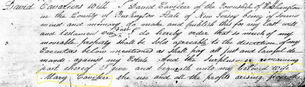
(Burlington County Wills Volume C-D, 1820-1836 Page 538)
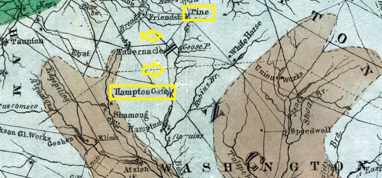
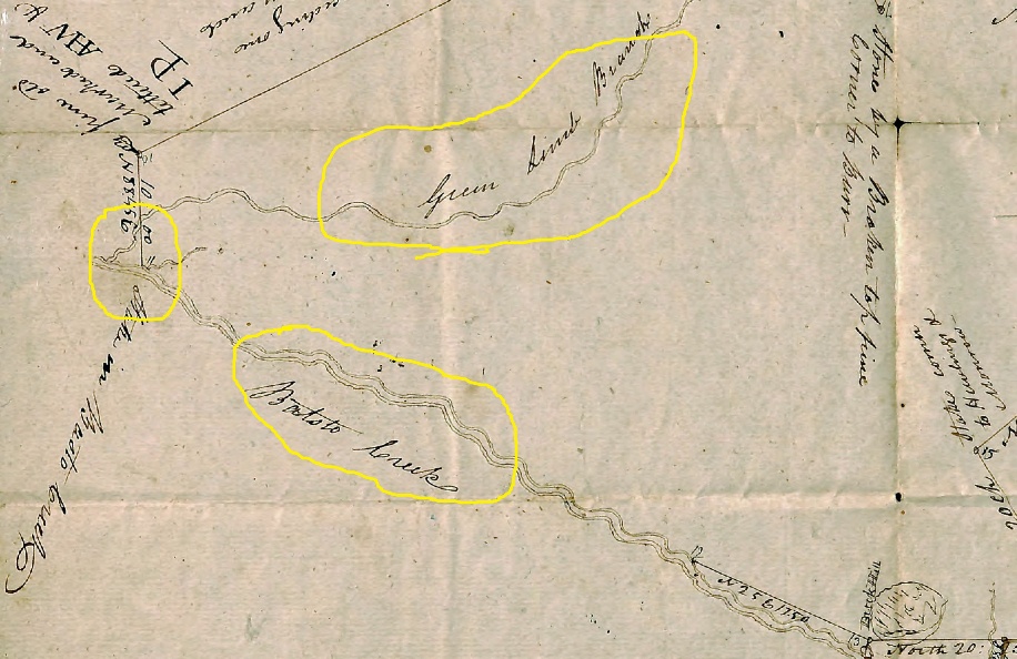
There are nine others who are mentioned in the will and the local place names used for their inheritance are interesting. Mary Taylor Smith gets 200 acres near “Barge” Bridge Road. Samuel Leeds receives land “near his dwelling ….. to the “little mill” (perhaps the turning mill on Green Limb Branch). John Clark inherits land near “Deep Run” and “Springers Creek.” Ann Leeds gets a cedar swamp north of the “White Horse Tavern.” The use of Barge Bridge Road instead of today’s “Bards Bridge Road” is particularly revealing concerning the source of that road’s name.
The will also mentions a “Mary Smith” (of late Mary Taylor) who is to receive a substantial part of the estate. The will goes on to say, “and after her decease to be divided equally among her children by the present husband.”
An 1829 Burlington County license listing confirms Mary Cavileer as a tavern owner.

(1829 list of Tavern owners, New Jersey State Archives)
Mary’s name appears in censuses of 1830 and 1840. In the latter census she lives alone and in the former census she is with one male between 20 and 30 years of age, as well as one female 15 to 20 years of age. Mary’s age in both census ranges indicates she was born in the 1770’s. She does not appear in the 1850 census. According to the 1849 Otley map, a J. Smith now owns the property. So, we can assume that Mary is deceased by that date.
And in 1840, “A Tavern Stand to let…. Known by the name of Hampton Gate,” is offered for “let” (rental) by William Stokes, on behalf of Jesse E Smith. It is not clear if Jesse is a minor or if Stokes is acting as an agent for the family.
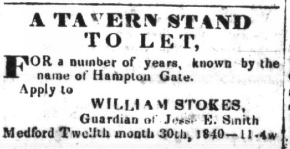
(New Jersey Mirror and Burlington County Advertiser, 30 December 1840)
This implies that Mary has passed by this date, or that she no longer can operate the tavern. Might Jesse be a son or relative of Mary? We also see a Josiah Smith as a hotel owner on Tuckerton Road in an 1850 business directory.
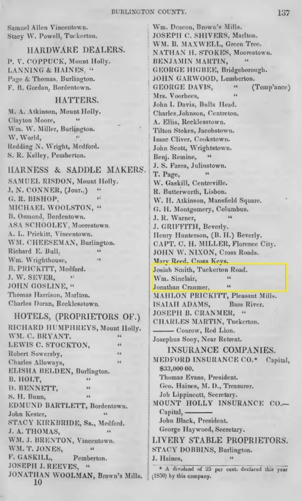
(Kirkbride S B, Kirkbride Business Directory, Trenton, N J, 1850)
So, we are dealing with two first names for the Hampton Gate site. They are Jesse Smith as noted in the 1840 ad, and Josiah Smith as seen in the 1850 directory. Perhaps there is a simple explanation. Both names are of Jewish origin and are derived from separate important biblical characters. However, there is also the Hebrew name “Jessiah,” regarded as a “variant” or “fusion” of Jesse and Josiah. Maybe both are the same person.
A search of the 1850 and 1860 censuses for these names only shows a Josiah Smith as a hotel keeper. But there is more confusion. A Josiah Smith is also a tavern owner not too far away.
When we look at a deed transfer in 1824 of land from Elizabeth McEwan to Josiah Smith, the property is listed on Atsion Road. Further deeds in 1856 (Josiah Smith to J. P. Smith) and in 1861 (estate of J. P. Smith to Manassas Delette) also mention Atsion Road as a location.
The 1826 tavern license for Josiah Smith lists his tavern as the Sign of the Buck. George Flemming, in his book “Brotherton,” states that the Sign of the Buck Tavern was at the intersection of Atsion and Red Lion Roads. He also states that the proprietor was Josiah Smith. Charles Boyer, in “Old Inn and Taverns in West Jersey” states likewise.
In his 1835 license application, Josiah still “occupies the old stand known by the name of the Buck Tavern.” By 1855 Josiah’s final license application shows that he has owned the tavern for at least 29 years. He asks the “judges to grant him a license to keep an inn and tavern in the house wherein he now resides.”
But based upon the 1850 Kirkbride Directory, a Josiah Smith owns a hotel on Tuckerton Road, not Atsion and Red Lion Roads. There have been several “misdirection’s” in the historical research for this site. We can confirm that David Cavileer purchased the property in 1812 from Caleb Cramer (Burlington County Deeds Book Y Page 31). And that in 1824 when he passed away, his estate was divided among eleven people. When the land was sold in 1875 to Mahlon Prickett (Burlington County Deeds Book A9 Pages 426-429), it was after an Orphan’s Court hearing that said the land could not be divided.
In 1860 an interesting story appears in Salem County’s “Salem Standard” newspaper which relates to Hampton Gate. A teenage boy had accused his father of murdering a peddler near Hampton Gate. Allegedly, the itinerant fellow was shot several years ago, buried in the woods, and had his wagon burned in a coal pit. You can read the full reported story at this location on our website. ( https://tabernaclehistoricalsociety.org/ths-home-page/events/murder-and-mayhem/#Unknown-Pedler) .
But this is not the only such story in the area. A Catherine Nehrwein was found dead in July of 1887 along the nearby railroad tracks of the New Jersey Southern Railroad. Her story is at the same web location as above.
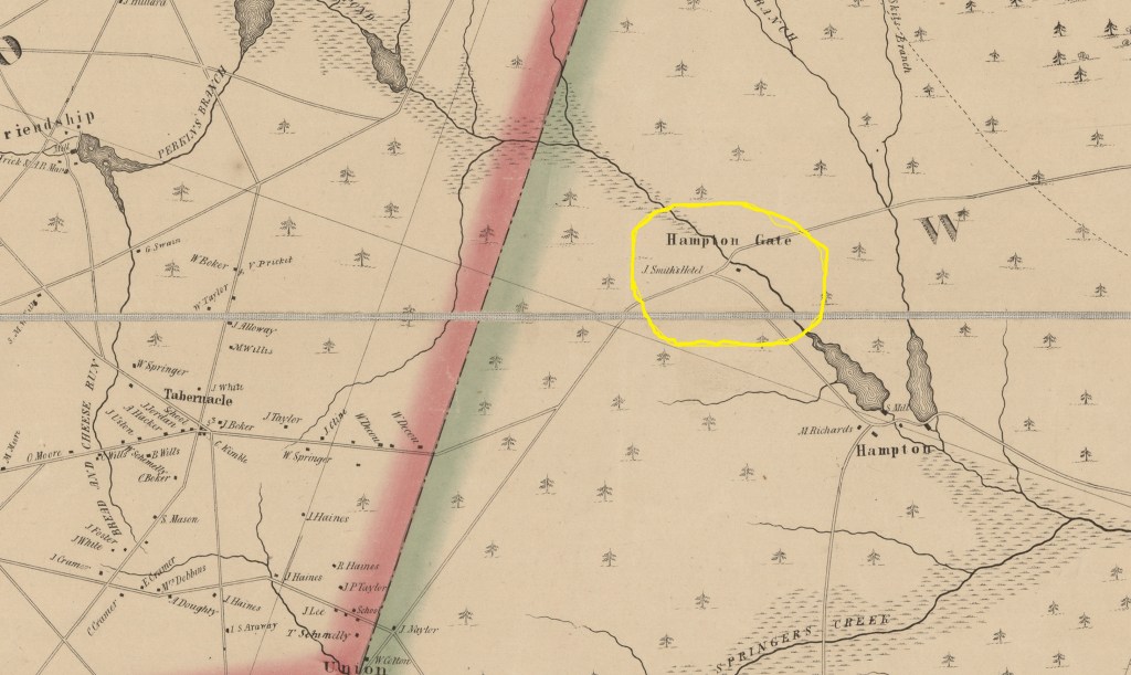
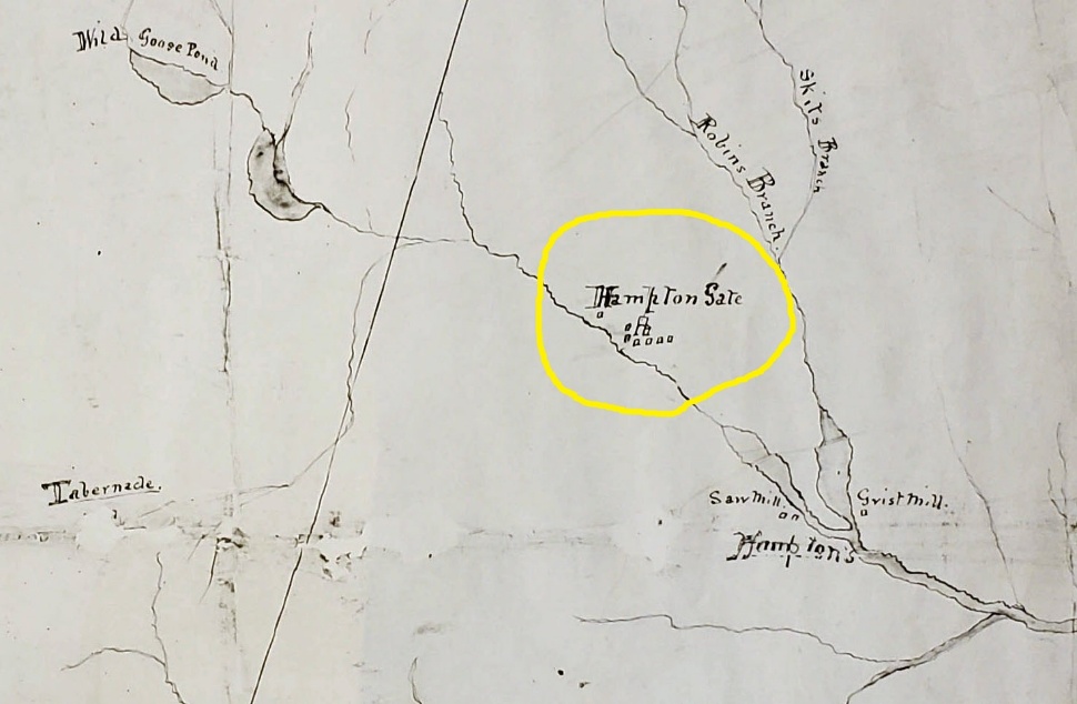
An interesting aspect is an 1839 geological survey map which shows a road in front of the potential tavern location. The road appears to be an extension of Irick’s Causeway, running from the Sooy Place Hotel at Pine. The map shows a symbol for “a hotel” just below the “e” in Hampton Gate. This is not the only map of the site which is available. Gordon’s 1833 map notes the same roadway.
(Rogers Henry D, A Geological Map of New Jersey, 1839)
However, as we closely look at both the 1849 and 1859 maps, we can see buildings noted. In 1849 a structure is seen between the Batsto River and the road to Hampton Furnace. It is labeled “J Smith’s Hotel.” And in 1850, Kirkbride’s directory shows Josiah Smith as a hotel

(Otley JW and Whiteford R, Map of Burlington County, Published by Smith and Wistar, 1849)
operator on Tuckerton Road, Burlington County. But there are some conflicting issues with this information.
So where was the hotel? Both of the above deeds in their land descriptions, mention “the stone hill” (1812), the “south side of the large stone hill,” (1875) and “a stake and stone on the top of the little hill” (1875). These references do not locate the hotel on Atsion and Red Lion Roads.
The 1859 map shows a building north of the roadway. While ruins have been found to the north, they very well may be what is left of a later farm. An Elliot Newman once lived in that area. The deed references seem to make it conclusive that the hotel building was to the south. This is also supported by several of the maps. While no ruins have been seen in this area, it’s logical to conclude that this is where the hotel once stood. And since it allegedly was a stone tavern, it’s quite possible locals removed the stone for other local construction purposes.
In 1859 the hotel is north of the roadway and is labeled “Hotel.” The name “Flemers” appears south of the roadway and seems to be someone’s homestead.
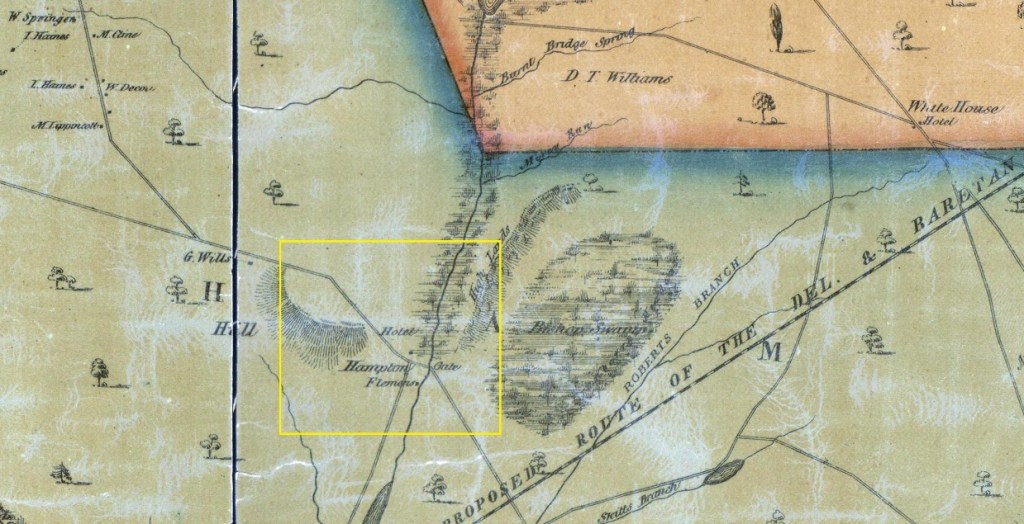
(Parry W, Sykes G and Earl F W, New Map of Burlington County, Published by R K Kuhn and J D Janney, 1859)
Census data can often confirm data, or it can provide new information. As we look over the 1860 census for Shamong, unfortunately we cannot find anyone named “Flemers.”
The New Jersey topographical map of 1860 has a great clue. If we look very closely within the yellow box, we can see the word “Hotel” and the representation of a building. It shows, as does the 1849 Otley map that the hotel’s location is between the road and the river.
While not 100 per cent conclusive because of the other maps, when coupled with the deed information it strongly suggests where the building was located.
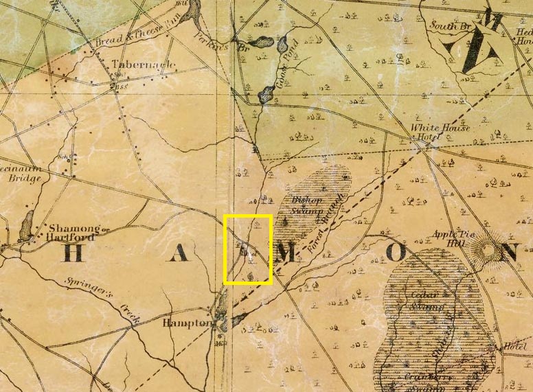
(Bond, H. G., Publisher, New Jersey Topographical Map, 1860)
An 1862 map of Washington Township reveals several buildings in the area.
(Washington Township, New Jersey map, Burlington County Historical Society)
The seven buildings are located east of the roadway and there seems to be a symbol for an Inn or hotel. We see a similar symbol marking the site of the nearby Whitehorse Hotel.
By 1876 Scott’s Atlas continues to show a building on the site. But the roadway to Hampton Furnace is between the structure and the waterway. The area is now called the “Atsion Property.”

Scott JD, Historical Atlas of Burlington County, Reprint of the Pemberton Township Historic Trust, 2002
Located in the same general area was a mill referred to for years as a Tunking Mill.” In short, this is a mislabeling of what was actually a “turning mill.” The “tunking mill” has been described as a huge mill which pounded ore into smaller pieces for use in an iron furnace. The nearest iron furnace was at Hampton, some four miles away. It had a separate forge nearby which would have been used for the same purpose. It was on a wide stream, the Skit Run Branch. The “tunking mill” was on a very narrow stream called the Green Limb Branch. The narrower stream would not have supported a large operation. Several deeds of the area reference a “turning mill,” and it is located right on the Green Limb Branch. Not more than four feet wide, it’s dam and the surrounding terrain supports the theory of a small operation.
An 1813 survey does not show the exitance of any kind of mill on the Green Limb Branch, where it approaches the Batsto River. If indeed there was a “tunking mill,” it or it’s ruins would have been shown in this era.
(Harker, Abel, Shamong Township Survey of 140 acres, NJ State Archives,1813)
The dam area is also in the midst of a cedar swamp. Notably, turning mills were used to cut wood at an angle, exactly as a cedar shingle would have been cut. An 1869 deed John Harker to William Thomas (Book A8 Page 587) cites the turning mill as a boundary point. And another deed in 1896 from William Towsend to Ellsworth Adams (Book 324 Pages 22-23) describes the same boundary point.
Maybe some day in the future more records will be located, which will help pinpoint the exact location of the hotel, as well as provide a clearer line of ownership for the property. Till then, this report can be used as a springboard to reach those goals.
