
The Eagle Hotel dates back to the latter half of the 1700’s. In 1799 Gideon Pharo (Farrow) was reported to be the operator. In 1830 James McCambridge bought the land as he acquired this and many acres of adjoining land, including Speedwell. The hotel was located on the once busy road today known as Eagle Road. Only a historical marker notes its location today. No foundation is visible but there are a few “cellar holes” which may locate its position.
As we trace the property back from James McCambridge, this deed (partial) is the second earliest one located.
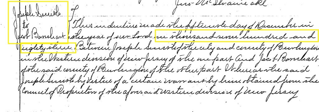
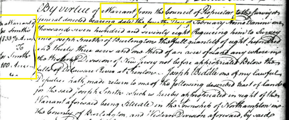
On 15 December 1783, Joseph Smith sold property to Jacob Barnhart. Joseph Smith had obtained the land from the West Jersey Council of Proprietors. The property was on the “east side of the road from Robbins Meadow to Tulpahockin Bridge and a little to the south of a road leading from Randolph’s Mill to Tulpahockin Cedar Swamp.” The sale price was “twenty pounds gold or silver.”
Over the years, beginning with the 1778 deed, and going through deeds dated 1815, 1820, 1830, 1836, 1842, 1870, 1927 and 1946, the property description remains exactly the same. Later renditions of the property, drawn with metes and bounds software, seem to indicate the property has substantially kept its original boundaries. Its pentagon shaped lot is 100 acres. It’s unusual for a property to keep its original boundaries, but this certainly did happen with the Barnhart property. Below is the original document showing the land transfer from the West Jersey Proprietors to Joseph Smith.
An 1812 map by William Watson shows the location of the Barnhart property.

On October 6, 1815, Jacob Barnhart sold this property to John Shields. Both parties lived in Washington Township. The price was $1000. The property was on the (see above) “east side of the road from Robbins Meadow to Tulpahockin Bridge (mostly today’s Eagle Road) and a little to the south of a road leading from Randolph’s Mill to Tulpahockin Cedar Swamp (perhaps today’s Speedwell Road). It is the same land that Jacob Barnhart purchased from Joseph Smith on 15 December 1783.
In December of 1820 the High Sheriff of Burlington County, Samuel Haines, sold the property to Aenas Murray for twelve hundred and ten dollars. Apparently, John Sheilds owed money and may have “left” the County. So, the Sheriff ordered the sale to satisfy the debt. The property was formerly known as Barnhart’s Tavern. Aenas Murray had been the person to whom Shields owed money.
The term “fieri facias” as seed in the Sheriff’s ad is “ is a legal phrase that commands a sheriff to seize and sell a debtor’s property to satisfy a monetary judgment owed to a creditor. Derived from Latin, it literally means “that you cause to be done” or “to cause it to be made”. The sheriff levies (seizes) the property and converts it into money through a sale to pay the debt.

Ten years later, in 1830, Aenas Murray transferred ownership to James McCambridge for just seven hundred dollars. The deed mentions “all and singular the houses, out houses edifices and buildings thereon erected.” Some reports (Charles Boyer) mention that McCambridge was operating the hotel as early as 1826 and that an Abner Cross had leased it prior to that. Possibly indicating that Aenas Murray never actually occupied the property. When Cross died in 1840 his estate only mentions land and a farm one mile east of Irick’s sawmill. It was purchased by John Lee for $896.00.
However, McCambridge seems also to have come into some financial problems within a few years. On the ninth of August 1836, the property was deeded to a James Maylin for $400.00. Maylin held the property until 1842 when it was resold to McCambridge for $350.00.
This deed and the 1836 deed share a common problem. The grantee in 1836 is James Maylin. Indexes for grantees and grantors that year confirm the name of James Maylin. In 1842 both indexes and the deed refer to a James “Miller” as the seller. Two obviously different names as a grantee in 1836 and a seller in 1842.
There does seem to be an explanation for this. The 1842 deed references the date the of an 1836 deed. It’s exactly the same as the 1836 deed. Confused? It seems that the name of James Maylin is some sort of a phonetic mispronunciation of the James Miller name! Most people signed deeds with an “x” and those who wrote them out wrote what they thought they heard.

While the 1849 map labels the site as “the old Eagle Hotel,” in 1859 the Parry, Sykes and Earl map does not label it likewise. It simply says, “Eagle Hotel, James McCambridge.”

In 1866 James McCambridge made tax payments to Woodland Township. He paid $69.72 in taxes to various government agencies on personal and real property valued at $4600.00. State tax is $3.68, County tax $31.00, Township tax $15.27, Road tax $13.34, School tax $3.45, Jones Mill school tax $1.98 and poll tax $1.00. Also noted on the same page are two other McCambridges, George and William.
However, just a few years later, on October 5, 1869, the Burlington County Chancery Court issues a decree.
On a complaint by Charles Holloway, Joseph Holloway and others, the property was up for sale at a public auction in Mt Holly, at the hotel of Joseph Keegan. While the actual court record is not available, it’s easy to suspect the issue was related to debt.

Just a few, short months later, on January twelfth, 1870, Special Master Ten Eyck deeded the land to Aaron Early. Early paid $750.00 for the entire 100-acre Barnhart Tract.

By 1878 the Cook and Smock map continues to call the site Eagle Hotel. This might lead one to suspect that the hotel was still in operation. However, the 1889 NJ Geological Map simply labels the area “Eagle.”

So, it is not really clear whether the hotel was in operation or not. No tavern licenses for this location are seen in the list of such licenses available in the New Jersey State Archives.
The Early family had ownership of the property until 1927. In a deed filed that year, Thomas Early, son of the first Early purchaser, Aaron Early, sold the property to Philadelphian George Schwartz. The sum is $1.00, and the legal property description is the same as the 1783 deed.
Finally, in 1946, Schwartz deeded the property to many members of the Cutts family. As of 2025 it remains in the family, now as part of Cutts Brothers, LLC.
Early United States Census information is not extensive. Sometimes early tax records are more valuable. A look at both these data sources does give us a little more information about Jacob Barnhardt, James McCambridge and other owners.
While there is no available census data for 1790 to 1820, there are tax records. Jacob Barnhardt in 1770 and again in 1774 was a taxpayer in Washington Township. In 1800, and again in 1810 he owned land, horses (2) and cattle (3).
The 1830 census does not contain a lot of personal information. However, it does list a James McCambridge of Washington Township. There are two males and six females in the household. One male is between 20 and 30 (born 1800-1810), while the other is between 60 and 70 (born 1760-1770). It’s quite probable that this is a father and son, both of whom are named James. We can infer this from the 1870 census, wherein there are two James in the family born within the time frames suggested by the noted ages in the 1830 census.
The 1840 census contains much of the same information but does not include the younger James nor the two younger males.
In 1850 James junior is a collier (one who burns logs over several days to make charcoal) and has nine children. As noted below, the 1849 Otley map states the property is the “Old Eagle Hotel,” leaving one to believe the hotel usage may be over.
By 1860 there are three James McCambridges in Washington Township. None is listed as a hotel operator. And as we look at 1870, we see the same result.
The Early family appears in several censuses during the time they owned the Barnhart tract. In all such documents they lived in Pemberton and were merchants. It’s quite likely they never lived in Eagle, and this may suggest that the hotel was long gone.
And finally, when the Schwartz family took over in 1946, census records became more muddled because the family is from Philadelphia. It’s very unlikely anyone was living at Eagle in mid-20th century.
Charles Boyer, in his excellent book Old Inns and Taverns in West Jersey, presents a 1936 era history of Eagle Tavern. What he has written is quoted in its entirety.
“One of the noted taverns of the pine belt was old Eagle Tavern, situated midway between the White Horse (Paisley) and Washington. The first tavern keeper, as far as is known, was Gideon Pharo, who was licensed in 1798. In the road returns for Burlington County for 1799, is a record of a road “beginning at the center of a public road leading from EayreTown to Tulpehocken, a short distance southwest of the public house of Gideon Pharos.” In 1810 Jacob Barnhart became the landlord and the house became known as Barnhart’s Tavern. John Shield followed Barnhart, but was only here for one year, when Abner Cross, a former workman at Martha Furnace, became the lessee. James McCambridge in 1826, announced that “he now dwells at that old and noted stand known by the name of Barnhart’s Tavern.” He kept this tavern for a number of years and soon became the owner of much of the adjacent land, including the famous Speedwell Furnace property. On a map of Burlington County, published in 1849, this tavern is marked “Old Eagle Tavern,” but by that time it had been abandoned, although the name was still retained.”
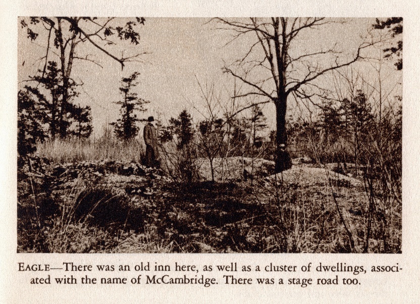
The best early view of the site has been preserved for us by Henry Beck, in his book, More Forgotten Towns of Southern New Jersey. He shows us a “cellar hole” on a slight rise of the landscape.
The history of Eagle also includes a nearby cemetery, a mile or so south of the hotel site. While today only one tombstone remains (from an 1839 Burial), others have reported many wooden grave markers (as many as 13) in the past. Not only have no records been found, but also the homesteads of those buried are also unknown.
Eagle seems never to have been a town or a hamlet and certainly did not have enough of a population to sustain a cemetery. The nearby communities of Speedwell and Friendship Bogs were larger. However, Friendship Bogs was most likely established in the latter half of the 19th century, much after the date on the remaining tombstone. Speedwell, a nearby Revolutionary War furnace town, certainly had the population. But the distance from Speedwell to Eagle is perhaps too far away to be designated as a cemetery for Speedwell’s deceased.
A summertime visit today to this site is possible. The sand road (Eagle Road) does have several “sugar sand “ patches but they are just beyond the Tavern site. A bigger problem is the chiggers and ticks in the woods about and around the cellar holes. Make sure you have applied your insecticide if you venture into the heavily wooded acerage!
